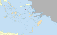


Patmos is a small Greek island in the Aegean Sea. One of the northernmost islands of the Dodecanese complex, it has a population of 2,984 and an area of 34.05 km (13.15 sq mi). The highest point is Profitis Ilias, 269 metres (883 ft) above sea level. The Municipality of Patmos, which includes the offshore islands of Arkoi (pop. 54), Marathi (pop. 6), and several uninhabited islets, has a total population of 3,044 (2001 census) and a combined land area of 45.039 square kilometres (17.390 sq mi). It is part of the Kalymnos regional unit. Patmos' main communities are Chora (the capital city), and Skala, the only commercial port. Other settlements are Grikou and Kampos. The churches and communities on Patmos are of the Eastern Orthodox tradition. In 1999, the island's historic center Chora, along with the Monastery of Saint John the Theologian and the Cave of the Apocalypse, were declared World Heritage Sites by UNESCO. The monastery was founded by Saint Christodulos. Patmos is also home to the Patmian School, a notable Greek seminary. Patmos is mentioned in the Christian scriptural Book of Revelation. The book's introduction states that its author, John, was on Patmos when he was given (and recorded) a vision from Jesus. Early Christian tradition identified this writer John of Patmos as John the Apostle, though some modern scholars are uncertain. As such, Patmos is a destination for Christian pilgrimage. Visitors can see the cave where John is said to have received his Revelation, and several monasteries on the island are dedicated to Saint John. The current mayor of Patmos is Grigoris Kamposos.
Quelle: wikipedia.org